
| ||

Tue 2026-06-16
Mon 2026-06-15
Sun 2026-06-14
Queer Fascism and the End of Gay History Sat 2026-06-13
Fri 2026-06-12
Thu 2026-06-11
Wed 2026-06-10
Mon 2026-06-08
Search
Archives
2024
12 11 10 09 08 07 06 05 04 03 02 01
2023
2022
2021
2020
2019
2018
2017
2016
2015
2014
2013
2012
2011
2010
2009
2008
2007
2006
2005
2004
2003
One good site
MDN
Nelson Minar
Blog licensed under a Creative Commons License
|
I just completed a project I’ve been working on for a few weeks, a vector tile map of American rivers based on the NHDPlus dataset. It’s mostly a demo project with readable source, but it’s also kind of pretty. 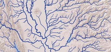 There are three and a half products:
Vector maps are exciting. The proprietary map world is moving steadily towards vectors; pretty much all mobile maps are vector now and Google Maps is switching to vectors on the desktop. The open source and data world is getting there too. Thanks to Mike Migurski there’s now an experimental OpenStreetMap vector service that’s very promising. Also my personal thanks to Mike: the genesis of this project was getting an hour of his time. |
|
