
| ||

Tue 2026-06-16
Mon 2026-06-15
Sun 2026-06-14
Queer Fascism and the End of Gay History Sat 2026-06-13
Fri 2026-06-12
Thu 2026-06-11
Wed 2026-06-10
Mon 2026-06-08
Search
Archives
2024
12 11 10 09 08 07 06 05 04 03 02 01
2023
2022
2021
2020
2019
2018
2017
2016
2015
2014
2013
2012
2011
2010
2009
2008
2007
2006
2005
2004
2003
One good site
MDN
Nelson Minar
Blog licensed under a Creative Commons License
|
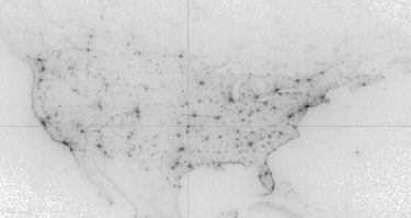 Here is the first map I ever published online, a visualization of what locations people were looking at on Google Maps on April 6, 2005. This was right after Google Maps added satellite imagery. Here's the official blog post about the visualization; the published image is gone, good thing archive.org has it. I wince to see the ugly stretched projection; I didn't know anything about maps, so I just plotted longitude and latitude as X/Y axes. (Cartographers call this Plate Carrée; it's generally a sign the mapper is clueless.) The greyscale histogram is not particularly good, although in my defense the original unscaled PNG was nicer. I think the whole thing started as a fun project to learn Sawzall, Google's 20% time in action. |
|
