
| ||

Tue 2026-06-16
Mon 2026-06-15
Sun 2026-06-14
Queer Fascism and the End of Gay History Sat 2026-06-13
Fri 2026-06-12
Thu 2026-06-11
Wed 2026-06-10
Mon 2026-06-08
Search
Archives
2024
12 11 10 09 08 07 06 05 04 03 02 01
2023
2022
2021
2020
2019
2018
2017
2016
2015
2014
2013
2012
2011
2010
2009
2008
2007
2006
2005
2004
2003
One good site
MDN
Nelson Minar
Blog licensed under a Creative Commons License
|
I'm a published cartographer! I contributed a couple of static maps of Enga Province in Papua New Guinea for the academic press book The Absent Presence of the State in Large-Scale Resource Extraction Projects. They're in chapter 3, Restraint Without Control, which talks about the interplay of the mining industry and local tribal fighting. You can read more about it on author Alex Golub's blog. There are high resolution versions of the maps on my site. 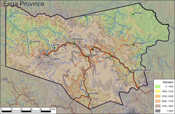 Alex is a friend from college, he knew I was interested in mapping and asked me to contribute some custom maps to help locate his narrative. PNG is a famously remote country and poorly mapped. Even in the modern era PNG map quality is very uneven. SRTM makes the topography map easy. But maps of human features are harder to come by. Google Maps and Bing Maps have very limited data. OpenStreetMap is much better and there are some specialist maps that are excellent. I wrote up a bunch of technical notes on making the map back when I did the work. QGIS and OSM were both essential. I had an idea it'd be nice to make maps for Wikipedia, one per PNG province. But the thought of dealing with Wikipedia politics was overwhelming. If there's a map advocate / mentor who would work with me I could probably get it done. |
|
