
| ||

Tue 2026-06-16
Mon 2026-06-15
Sun 2026-06-14
Queer Fascism and the End of Gay History Sat 2026-06-13
Fri 2026-06-12
Thu 2026-06-11
Wed 2026-06-10
Mon 2026-06-08
Search
Archives
2024
12 11 10 09 08 07 06 05 04 03 02 01
2023
2022
2021
2020
2019
2018
2017
2016
2015
2014
2013
2012
2011
2010
2009
2008
2007
2006
2005
2004
2003
One good site
MDN
Nelson Minar
Blog licensed under a Creative Commons License
|
Thanks to a neighbour I learned about Sanborn Maps, an
amazing historical resource for maps of American cities. The Sanborn
Map Company drew maps of American cities from 1867 to 1970 for sale
to the fire insurance industry. They're incredibly detailed drawings
of every building's shape and structural details with annotations of
nearby ovens and fire hydrants. There's a significant collection of
these maps at the Library of Congress, since digitized by ProQuest and often
made available for online PDF download via your local library.
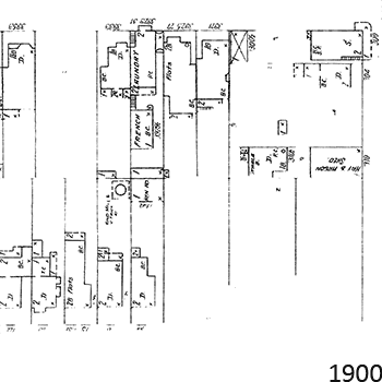 What I find most interesting are the ephemera, the sheds and workplaces. In 1900 my house had a big hen house, behind me was a French laundry, and the block had three windmills pumping water. In 1914 my hen house had turned into a third apartment, the laundry became a bakery (along with two others on the block) and the windmills were all obsoleted. And by 1950 my house is entirely new, the bakeries are all gone, but now there's a print shop in someone's back yard. There's an enormous amount of data about American city development, the problem is it's all locked away on paper or, if you're lucky, microfiche. It's great that we have our libraries and companies like Google and the Internet Archive doing so much archiving work, but we've a long way to go before all this data is digitized and indexed. |
|
