
| ||

Tue 2026-06-16
Mon 2026-06-15
Sun 2026-06-14
Queer Fascism and the End of Gay History Sat 2026-06-13
Fri 2026-06-12
Thu 2026-06-11
Wed 2026-06-10
Mon 2026-06-08
Search
Archives
2024
12 11 10 09 08 07 06 05 04 03 02 01
2023
2022
2021
2020
2019
2018
2017
2016
2015
2014
2013
2012
2011
2010
2009
2008
2007
2006
2005
2004
2003
One good site
MDN
Nelson Minar
Blog licensed under a Creative Commons License
|
I like maps. Some friends and colleagues are making some beautiful map and geographic based art that would make nice Christmas gifts. (For others! I’m not hinting, have these already!) Bill Morris makes painterly prints of satellite photographs. You can read about his process in detail. In short, he takes satellite images from Planet Labs and then pushes them through customized machine learning software to render them like paintings. They’re beautiful. 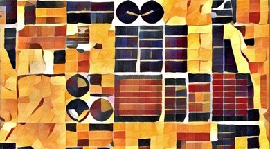 Rachel Binx makes geographic style products. Jewelry, clothing, and posters all custom made for someone’s personal geography. One-off design and fabrication like this is really ambitious and she delivers well. 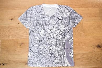 Benjamin Grant of the Daily Overview blog has a new coffee table book of aerial and satellite imagery. It sounds simple but he has an excellent eye and editor’s hand. It’s lovely. 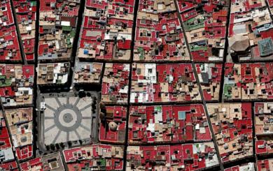 Jared Prince of Muir Way made a high quality print of a map of American rivers. He was inspired by my river map but ended up recreating the whole thing from scratch with a much better result than mine. The print quality is excellent too. 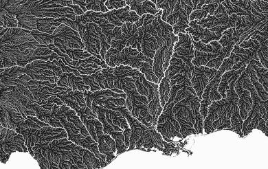 |
|
