
| ||

Tue 2026-06-16
Mon 2026-06-15
Sun 2026-06-14
Queer Fascism and the End of Gay History Sat 2026-06-13
Fri 2026-06-12
Thu 2026-06-11
Wed 2026-06-10
Mon 2026-06-08
Search
Archives
2024
12 11 10 09 08 07 06 05 04 03 02 01
2023
2022
2021
2020
2019
2018
2017
2016
2015
2014
2013
2012
2011
2010
2009
2008
2007
2006
2005
2004
2003
One good site
MDN
Nelson Minar
Blog licensed under a Creative Commons License
|
With the 2011
floods of the Mississippi river there's real
concern that the Mississippi might jump
its channel at the Old
River Control Structure and take a shorter path through the
Atchafalaya basin, changing the structure and economy of half of
Louisiana. In the Internet discussion an astonishingly beautiful set of
maps from 1944 keeps turning up.
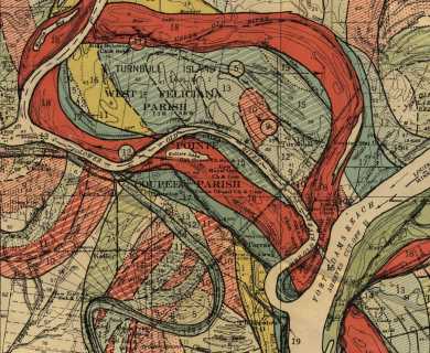 The report and maps are available for download from the Army but the files are big and pretty unwieldy. I've resized the rectified TIFFs to 25% and uploaded them to Flickr: you can browse them in this Flickr set. The one single image I recommend is Plate 22 Sheet 13: it shows the adjacency of the Mississippi and the Atchafalaya, connected by the Old River where the current water control system is threatened. For a different perspective, check out all the maps assembled into one long picture. It'd be neat to see a zoomable version of this to full resolution.
Update: why yes, it would be neat to have a zoomable version. Try it!
|
|
