
| ||

Fri 2026-05-15
Thu 2026-05-14
Tue 2026-05-12
Sun 2026-05-10
Fri 2026-05-08
Kyle Kingsbury Podcast Podcast Mon 2026-05-04
Sun 2026-05-03
Fri 2026-05-01
Thu 2026-04-30
Wed 2026-04-29
Tue 2026-04-28
Search
Archives
2024
12 11 10 09 08 07 06 05 04 03 02 01
2023
2022
2021
2020
2019
2018
2017
2016
2015
2014
2013
2012
2011
2010
2009
2008
2007
2006
2005
2004
2003
One good site
MDN
Nelson Minar
Blog licensed under a Creative Commons License
|
Last Sunday I had the pleasure to participate in making an aerial map, a very detailed overhead image of Dolores Park taken from 200’ to 400’. The fine folks at Public Laboratories have published the result. A couple of direct links: a full page slippy map and aerial video. I also got a nice single shot of the new Dolores Park playground (full size). 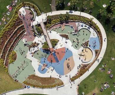 This kind of mapping comes from Public Laboratory, a cool non-profit helping ordinary people make their own aerial maps. You don’t need a satellite or fancy cameras on a plane to make a “satellite map”. All you need is a kite or balloon, a cheap point and shoot camera, and a little software. I particularly like how low tech the setup is. The lift comes from something as simple as a mylar balloon filled with helium (we used a car dealership ad balloon). No fancy cradle, just some rubber bands holding the camera to a plastic soda bottle with the soda cap as the clamp. And no special camera, just an ordinary consumer camera set to continuous drive with another rubber band holding down the button. Launch, fly for awhile, pick the best photos, then stitch them together into a map. (That last part takes some effort; you can do it by hand in Photoshop or use the MapKnitter web app). The Dolores Park shoot was mostly for fun, a nice way to be outside on a sunny day and excite a bunch of kids. But Public Laboratories participates in more serious projects too, like documenting the Deepwater Horizon oil spill. A key thing about this kind of mapping is anyone can do it relatively cheaply and quickly. You can also fly other sensors, they’re doing a lot of work in environment monitoring, Many thanks to Stewart Long and Bobby Sudekum for letting me tag along on the fun photo shoot. |
|
