
| ||

Tue 2026-06-16
Mon 2026-06-15
Sun 2026-06-14
Queer Fascism and the End of Gay History Sat 2026-06-13
Fri 2026-06-12
Thu 2026-06-11
Wed 2026-06-10
Mon 2026-06-08
Search
Archives
2024
12 11 10 09 08 07 06 05 04 03 02 01
2023
2022
2021
2020
2019
2018
2017
2016
2015
2014
2013
2012
2011
2010
2009
2008
2007
2006
2005
2004
2003
One good site
MDN
Nelson Minar
Blog licensed under a Creative Commons License
|
GPS is one of the wonders of the modern age (RIP, LORAN). But while GPS is
great for showing your position, it's
not so good at showing altitude. Part of the problem is the satellite geometry makes for poor triangulation of elevation. But worse, elevation itself is difficult to define.
If you're flying a plane, what you care about is how far you are above the ground (AGL). GPS won't tell you that since it doesn't know where the hills are. But GPS can tell you your altitude above sea level (MSL), which you can then compare to a map which shows terrain in terms of MSL. But where is sea level? Annoyingly, that's locally defined. Naively you'd just measure your distance from the center of the earth. Which is more or less what GPS does in that positions are defined relative to WGS84. The earth's not quite a sphere, so WGS84 is actually a pole-flattened spheroid, the polar distance is 0.335% shorter than the equatorial. GPS calculates your altitude above that spheroid. But the earth isn't a uniform object, it's lumpy. I don't mean the mountains, but rather the varying density inside the earth causes ripples in the gravimetric field. If you could conceptually flood the earth with enough water to cover all the mountains, the resulting global sea would not be flat. 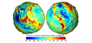 One last bit of detail: how do we know where the GPS satellites are? Their position is measured and updated regularly from ground stations. But everything in the universe is moving, so what do you measure position relative to? Answer: quasars. Astronomers define the International Celestial Reference Frame relative to the position of 212 quasars. Those quasars are themselves moving, but they're so far away that their apparent motion to us on earth is near zero and so we pretend they're fixed landmarks to reckon against. I love how GPS combines deep space astronomy, orbital mechanics, gravimetry, geology, and good old fashioned geography and survey work to tell us where we are with some accuracy. And don't forget special and general relativity, too! |
|
