
| ||

Fri 2024-04-19
Thu 2024-04-18
Mon 2024-04-15
Butterick’s Practical Typography Sat 2024-04-13
Fri 2024-04-12
Wed 2024-04-10
Boy Meets Boy Meets Boys’ Love Tue 2024-04-09
Mon 2024-04-08
Search
Archives
2023
12 11 10 09 08 07 06 05 04 03 02 01
2022
2021
2020
2019
2018
2017
2016
2015
2014
2013
2012
2011
2010
2009
2008
2007
2006
2005
2004
2003
One good site
MDN
Nelson Minar
Blog licensed under a Creative Commons License
|
I
like my iPhone tracking where I've been; my only complaint with
Apple is they didn't disclose this useful feature and give me access.
But it's not much hacking to get at the data, so I made a map. Red is
cell phone towers, blue is wifi nodes. The map looks correct to me; I
did a lot of small plane trips in the last year.
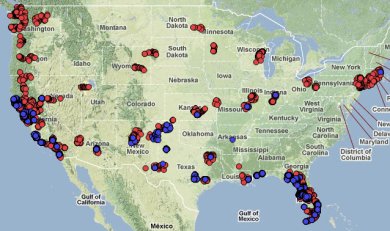
On reflection, there's too many points (500+) inside
San Francisco, including some in the water, for this to be just cell
tower locations from Apple's database. Maybe it is my calculated position?
The primary key for the database was named by Apple as MCC+MNC+LAC+CI,
which
apparently
is the "Cell Global Identity". The iPhone only keeps one fix for each;
no idea why some are in the water.
Technical details on my secret work blog. The main thing is two tables called CellLocation and WifiLocation which map tower ID or WiFi MAC to a latitude and longitude. The table's big, some 32,000 cell towers and 170,000 wifi nodes. I wrote some quick code to convert the data into GeoJSON and map it with Polymaps. I'd link the zoomable map, but it's personal data and the code isn't optimized. |
|
